
Hats
The Sun-Smart Collection
Click here to edit the text and include the information you would like to feature.

Shoes
Comfort X Design
Click here to edit the text and include the information you would like to feature.

Bags
Transport In Style
Click here to edit the text and include the information you would like to feature.
Hats
The Sun-Smart Collection
Click here to edit the text and include the information you would like to feature.
Shoes
Comfort X Design
Click here to edit the text and include the information you would like to feature.
Bags
Transport In Style
Click here to edit the text and include the information you would like to feature.
- Experience Architect -

Reversal
Starting with the prefix “trans”, which provides a lens from which analyze and understand the political, geographical, economic, or social watershed issues of the past, present and future, we exist and operate in a global age of boundaries. Water transverses through lands, challenging the very boundaries that we create to control it. To examine how water has shaped the way people live, I have chosen to focus our study on the largest river basins in Asia --- the Great Mekong.
Mapping - GIS, Rhino, Adobe Ai
Project type: Experience & Service Design, Design Research
Site Location: Phnam phen, Combodia
Junior 2nd semester architecture optional studio
My role: Individual Project; Research Team leader
Skills: Rhino 3D modeling, PS rendering, Adobe PS & Ai
Design Research, Insight Generation Ethnographic
Synthesis, Prototyping, Storytelling
This project starts with a team comparative research on three of the world's largest bodies of water: Mississippi, Mekong, and Rhine. Based on the research, we developed our own individual design to tackle on a specific water-related problem.
To view the team research prior to my design, please click here:

Story
The Mekong River is divided into upper and the lower basins. The upper basin falls mainly within China’s borders and its upstream location effectively allows for a chokehold on the river’s lower riparian states. China’s effects on the river are most evident in its extensive dam projects--hydropower is second only to coal as the country’s largest energy source. This represents a larger shift by the government toward renewable energy in the wake of rapid environmental decline and social unrest due to air pollution in recent years. Luckily for China, authoritarian governments have a much easier time than democracies commissioning dams, which often cause mass displacement of populations and destruction of local ecosystems. China currently has seven dams completed in the upper basin, with another 20 set to be finished in the near future.
The prospect of developing the Lower Mekong River's hydropower potential has long been of interest to governments in the region with plans being drafted as early as 1960. However, the process was begun in earnest in mid-2006, when the Governments of Cambodia, Laos and Thailand granted approval to Thai, Malaysian, Vietnamese, and Chinese companies to investigate eleven mainstream hydropower dams. If all of these projects are built they will transform the one of the world’s most iconic rivers, and the second most biodiversity river globally, into a series of reservoirs. Xayaburi and Don Sahong have already begun construction and preparatory work has commenced for Pak Beng, the third dam to move forward on the Mekong mainstream. These three dams alone are predicted to have negative transboundary impacts on the environment and people through the Mekong Basin. If the remaining eight proposed dams are built, they seriously jeopardize the future of the Mekong as a life-sustaining ecosystem.
The rapid expansion of hydropower and its predicted irreversible transboundary impacts on the environment and people across the region who depend on the Mekong River, threatens the development of all countries who share the Lower Mekong Basin, with downstream Cambodia and Vietnam at greatest risk. By changing the river's hydrology, blocking fish migration and affecting the river's ecology, the construction of dams on the Lower Mekong mainstream will have repercussions throughout the entire basin.
Dam Analysis - GIS, Rhino, Adobe Ai
[Source - Mouth Diagram]

Lower
Upper
Diagram - Icon made by Adobe Ai
Dam
Built
Water flow
Water flow
Fish Migration
Deforestation
Sediment
Eco-system
Fishery
Farming
Broken
Families
Seasonal
Drought & Flooding
The plan to build a series of dams on the Mekong main stem in Laos and Cambodia presents a serious threat to the river’s ecology and puts at risk the well-being of millions of people dependent on the river for food, income, transportation and a multitude of other needs. If all 11 dams one the mainstream are built, they seriously jeopardize the future of the Mekong as a life sustaining ecosystem.
Ideation
The cartographic directions are cultural constructions; tools developed by humans, for humans. Water, however, does not follow any certain direction, whether north, south, east or west. A River cannot be ruled by any human-imposed orders; it flows following the laws of gravity and nature – from high to low, from source to mouth.
The view which will serve as the foundation for our watershed architecture requires a radical reorientation, an entirely new approach to understanding watersheds. Watershed architecture requires an entirely holistic understanding of river basins.
[Device - Reversal]

By rejecting the “boundaries” in which we normally view watersheds while simultaneously revising the research concept [Trans-boundary], I proposed the idea [Reverse].
In contrast with the natural gravity directed flow of water, I suggested a hypothetical, reversal process by directing the downstream environmental consequences which devastate downstream families' livelihoods, back upstream. This was done with the hope that authorities operate dam constructions upstream could better and more vividly understand the sufferings downstream low-income people are undergoing. With the understanding that the downstream destruction will eventually influence the upstream people's livelihood and through compassionate lenses, authorities would develop much more sustainable and long-lasting solutions which could not only boost economic growth but also improve the life quality of every individual living along the Great Mekong river.
Hypothetical Model Analysis - Rhino, Model Photos, Adobe Photoshop + Ai
To embody such an idea, I designed a conceptual physical model by using plexi glass, basswood sticks, wires, and cotton threads. Each plexi glass represents the geographical locations of the 14 major dams from higher latitude to lower. By soaking the ends of the threads from the highest plexi glass with water colored in red, the red coloring gradually suctions to the lower panel. This mimics the process of the upstream damming bringing catastrophic influences to the downstream.
When viewed horizontally, the wood sticks protruding out from the bottom board are connected by metal wires and levered in the middle. The see-saw device can be toggled up and down to demonstrate how the downstream and upstream are in fact mutually influencing each other. The interdependent relationship can be reciprocal or subversive. Both authorities and the public could make efforts to save the Great Mekong Ecosystem and save people living along lower Mekong from misery, if they could understand current emergencies happening downstream.


Model Photo + Photoshop Edits
HOW MIGHT WE
develop River Mekong both sustainably and economically, to eventually bring locals better lives?
To answer the question myself, I propose an architectural solution that can provide spatial solution to feed the needs of lands and decrease the environmental destruction in general. Such a solution can be applied to different sites across countries and adapted itself to overcome different local issues.
My proposal here serves as an experimental model, which tackles on general problems every section of Mekong river suffers from, while presenting specific functionality to one unique site to conquer specific local dilemmas.
Design
[Spatial Concept]
Salinity has long-term been a huge problem in the Delta area. It highly jeopardizes local farming and deprive lots of fresh water. Natives have been suffering constantly from severe flooding and shortage of fresh water and food. Such environmental disasters also lead to enormous decline on crop production, resulting in huge decrease in family income. The proposal is aimed to provide local farmers more lands by using vertical space, moving everything above the ground level. By lifting everything to the air, people and lands will be distant from the surrounding waters, away from flooding and salinity, offering more free space for farmers to plant. The architecture itself will also be equipped with water transporting, purifying and hydropower system buried in the structure that will satisfy the water and electricity use of the entire building.

Hand Drafting + Adobe Photoshop & Ai
Besides fulfilling agricultural needs, the architecture can additionally provide recreative space for locals to enjoy their lives and attract more tourists. Raised up floor plates function as observatories, bridges and dwelling, for people to observe, transport and gather. It opens up possibilities of vivid entertaining choices away from merely striving for livelihood and introduce other approaches bringing economical growth.


Raised-up Farming
Irrigation system is pre-designed as part of the structure to satisfy the excessive water needs of farming and planting. Water sucked from underground will be transported all the way to the top. There are drainage systems one every farming floor to collect extra water and keep recycling around the entire building. The glass roof is designed to offer enough natural sunlight.


Enormous staircases are designed to provide more gathering spaces to stimulate communication and recreative activities. People can take a peaceful break from everyday hard work by sitting on the stairs and to observe the city they live in and help to build up.

Observation Deck


Recreative Space
Bigger space provides bigger possibilities. Though living in poverty, people who have been working diligently for their entire life deserve to enjoy their lives a little bit more. As a designer, I sectioned off space for the the purpose of entertainment.

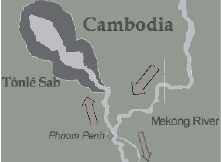
[Site Chosen - Phnom Penh, Sisowath Quay]

Phnom Penh, Sisowath Quay, Combodia
Tonle Sap
Mekong River
Mekong River
Sit Mapping - Adobe Ai
A seasonally inundated freshwater lake, Tonlé Sap Lake, and an attached river, the 120 km long Tonlé Sap River, connects the lake to the Mekong River. Annual fluctuation of the Mekong's water volume, supplemented by the Asian monsoon regime, causes a unique flow reversal of the Tonlé Sap River.

Google Photos

Every year there is an important river festival held here in this confluence. The festival marks a reversal of the flow between the Mekong and Tonle Sap rivers. Essentially, the festival is a time to give thanks to the rivers as they provide the region with fertile farming land and plenty of fish. The festival is focused on boat races and concerts which attracts tons of people coming to celebrate, not just natives but also tourists.
[Idea Evolved - Final Design]

Bearing in mind the functionality of agriculture and environment conservation, adding on the special features brought the river festival, this architectural complex is served as farm lands, hotel, theatre, observatory, fresh water storages, bridge and recreation center.
Model Photo

Rhino + Enscape & PS
As for locals, the middle farming areas are vital for their living; however as for tourists, the farming terraces become a beautiful landscape they could visually appreciate and at the same time learn more about the local life. Enveloped space motivates communications and interactions. It fosters a community space that interweaves the lives of outsiders and insiders and breaks the geographical boundary between upper Mekong river and lower Mekong river - bridging peoples from two sections to create better mutual understanding and compassion.

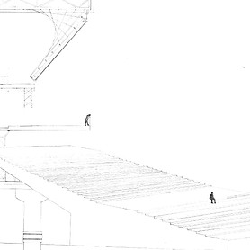
[Section Drawing]
Hand drafting + PS & Ai
Double click to see details

Plan Drawing - top floor

Standard hotel rooms - Single & Double
Rhino + Enscape

Plan Drawing - bottom floor

Located over the confluence of two river tributaries, the eco-friendly complex fully utilizes the hydropower generated from running water to offer power to the entire building. The four pillars function as main supportive structures as well as water pumps. Water pumping and purification systems are hidden inside, transporting clean water underground to fulfill people's water use. Water pipes are hidden inside the walls and floors where water is running to every corner of the complex. Some of the water will be transported to the sprinkling systems equipped on the top ceiling, supported by steel girders. The sprinkler system turns on automatically in the early morning and early afternoon to offer moisture to the greens and crops planted on the middle farming terrace, without bothering tourists during their active periods. Efficient drainage systems decrease the waste of water and improve the water recycle.
Photo Gallery of Physical Model:


“Designing a river basin successfully means adopting an attitude of [trans];
trans-boundary, trans-national, transformational, trans-watershed architecture.”